By Ciara Wolfe BSCO Executive Director
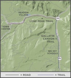
Lone Peak Trail connects Big Sky’s Meadow Village to Gallatin Canyon. This 8-foot wide asphalt trail follows the south side of Lone Mountain Trail, also known as Highway 64, for 3 miles from Town Center to the intersection of Lone Mountain Trail and Highway 191 in the canyon. From there, walkers, runners and bicyclists can join the Gallatin Canyon Trail for an additional 2.5 miles of asphalt trail that continues south to Ophir School.
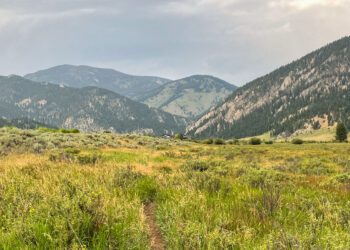
Don’t let the paved surface or distance deter you from trying this trail out. Coming from Town Center, you coast downhill around large curves, through a forested area, and over the South Fork of the West Fork of the Gallatin River. The gurgling river provides a pleasant background as you enjoy the scenery during the lower third of the trail.
You may even get the chance to view the resident bighorn sheep herd that frequents the north side of Lone Mountain Trail near the pedestrian bridge over the South Fork of the West Fork of the Gallatin River. Just make sure to save some energy for the 3-mile walk, run or bike back to Town Center—and enjoy the view of Lone Peak as you make the trek back.
For more information about Big Sky’s parks, trails and recreation programs, visit bscomt.org. The Big Sky Community Organization is a local nonprofit that connects people to recreational opportunities by acquiring, promoting and preserving sustainable places and programs for all.
Distance: 3 miles one way
Difficulty: moderate
Elevation gain: 300 feet
Surface: paved
Uses: walk, run and bike
Directions: You can start at either end of the trail. From Town Center: Catch the trail on the south side of Lone Mountain Trail near its intersection with Ousel Falls Road. From Gallatin Canyon: Park at the Big Sky Conoco located at the Intersection of Lone Mountain Trail and Highway 191 and head west.


