By Paul Swenson EBS COLUMNIST
Have you ever been hiking or skiing in the backcountry and noticed what looked like a big chunk or boulder of concrete? When I was a kid, I would. I would stop and look around for an old house or cabin, or mining shack, that might be the source of this material. I wanted to find the treasures buried by the homesteaders, hidden away from the marauding bandits. But alas, I never found an old foundation, a mine, or my fortune.
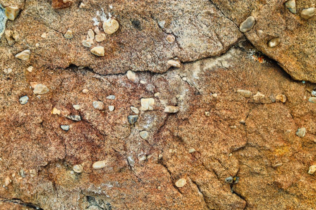
But it still excites me to find these blocks of rock in the backcountry, but now I know they are not concrete made by man, but rather a type of sedimentary rock called a conglomerate. The riches of these rocks are not the monetary kind you want as a kid, but rather a treasure map of sorts to the geologic history of the Rocky Mountains.

A conglomerate is defined as a number of different entities or parts put together to form a whole, but each still retains its identity. As a rock, a conglomerate usually contains large pebble- to boulder-sized clasts that are surrounded by a sandy matrix. Each of the clasts retains its original properties like composition, color, and rock type. Usually the rocks that survive to make up the conglomerate’s clasts are the ones that are resistant to erosion: limestone, chert, sandstone, gneiss, and granite for example. Quite often a geologist can identify the formation that was the source for the clasts.
Conglomerates usually form as a result of a landmass that has been uplifted and exposed to the erosional forces of water. Looking at the clasts and matrix one sees rounded boulders, cobbles, pebbles, and sand. It looks like the cross section through a gravel pit. These indicate that there was a lot of energy in the water that moved the sediment along, like a fast-moving river. And the larger the clasts in the conglomerate, the higher the energy of the water would have to be to move them.
Let’s use the Gallatin River as our modern-day analog. Driving through the canyon you see huge boulders and cobbles mixed with sand in the riverbed. During spring runoff, you can even hear these boulders moving and colliding as they are transported along by the rushing water. Then as you move off into the valley, the river loses gradient and the cobbles get smaller in the gravel bars as you move away from the mouth of the canyon. All the way down by Manhattan the size of the sediment has now become mostly golf-ball size pebbles and sand. Keep traveling down to Three Forks and the sediment is now predominately marble size gravel and sand. Drawing on these kinds of observations we can infer the type of depositional environment a conglomerate formed in. In addition to the clast size determining the gradient of the stream or river, they can also inform us as to the direction of the flow of the water that deposited them.
One can put this into practice by observing the largest collection of conglomerates in our region, Sphinx Mountain. The entire mountain, and the smaller “Helmet,” are made up of thousands of feet and many layers of the Sphinx conglomerate. It is the only place in the region where you find this formation. It is the erosional remnant of what’s called a synorogenic foreland conglomerate.

Synorogenic means formed during a mountain building event known as an orogeny. As the land is compressed and folded, the crust thickens and increases in elevation. In front of this deformation there is usually a basin formed, called a foreland basin. And it is into this basin that rivers carry sediments from the rising mountains.
In our region this orogeny was creating the Rocky Mountains to the west. As the mountains rose the youngest rocks from the top formations eroded first. With continued erosion, older rocks would be exposed and eroded, and so forth. This leads to an “unroofing” sequence in the conglomerate. The layers of conglomerate on the top of the Sphinx contain the oldest (Paleozoic limestones) clasts from the dissected mountains to the west, while the layers at the bottom of the mountain contain the youngest clasts (Mesozoic sandstones and limestones). For the Sphinx conglomerate all this happened between 75-56 million years ago.
After 56 million years ago the basin itself was affected by the continued deformation of the orogeny. The layers of the conglomerate were folded, uplifted and then eroded. It is a synclinal fold of the conglomerate that kept the last remnant of this tumultuous period preserved.
So next time you are over on Dakota, Shedhorn, or up on the tram, look to the south and observe the Sphinx and its “syns;” synorogenic deposition preserved by a syncline.
Paul Swenson has been living in and around the Big Sky area since 1966. He is a retired science teacher, fishing guide, Yellowstone guide and naturalist. Also an artist and photographer, Swenson focuses on the intricacies found in nature.


